|
Ethan's Ark Hampton to Florida |
| Home Dunedin to Chesapeake Oct., 2008 Hampton to Florida Oct., 2009 Florida to St. Mary's County April, 2010 St. Mary's County to Florida Oct, 2013 Hudson to Bahamas and Back June, 2017 Contact Us |
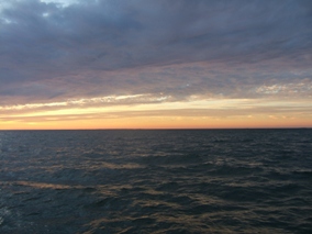
After spending the winter of 1008/2009 in Richmond Va. I told my wife that another winter in Richmond was intolerable. It was very difficult for me due to not being able spend time on the boat, and spending most of the time indoors. I did a lot of things around the house, but, for various reasons, Richmond is not for me. Accordingly, I made plans with Rob Leyden to help me move the boat from Hampton Va. to Florida. I had no clear idea of where to go in Florida, but it seemed like a good first stop would be in New Smyrna Beach, where I intended to transport Rob back to Dundedin, and to catch my breath while I decided what was to come next.
During the spring of 2009, I build a new dinghy for the “Theodore Robert”. The dinghy I built was a kit called the “Passage Maker” that is sold by “Chesapeake Light Craft”. The dinghy is 12 ft long with a transom bow and a lot of rocker. It is lapstrake stitch and glue construction and weighs 90 pounds. The official carrying capacity of 650 pounds. It can be rowed, sailed or can take a 2 hp outboard! Pretty cool in my book.
I wanted to get underway around the first of October before it got too cold. (I do not like sailing in the cold and damp of a Virginia fall). Rob was unable to join me as soon as we both would have liked and we both figured on about a week of preparations before getting underway. Rob was able to leave on the 2nd of October and arrived in Richmond on the third.
Our plan was to get underway on or about the 10th of October, but we were delayed for a couple of days trying to get things done, then on the 12th, the weather got really bad, at least from our point of view. Hi 40s for the lows and raining almost constantly. This went on for about a week, and we decided to wait it out and finally got underway on the 19th of October. This was about 10 days later than we had hoped, but so it goes.
We got underway in pretty cold weather and motored out into the Chesapeake, south to the York river, across the York to the Elizabeth river then anchored in a small basin just north of the entrance to the Dismal Swamp canal. We had not yet decided which route to take, but when we got up early enough on the 20th we decided to lock through and take the Dismal Swamp canal route. We made it through both sets of locks, and ended up tied to the wall near the public docks in Elizabeth city N.C. We had arrived just too late for the wine and cheese event that Elizabeth city hosts, so we had a nice dinner and turned in for the night. The next morning we got a pretty late start, but the weather and the current were with us so we cruise down the Pasquotank river and headed across Albemarle sound. At this point I decided to take the Pamlico sound route, but due to there not being a safe enough anchorage, (I’m pretty picky), we stopped for the night in Manteo at the Manteo Waterfront Marina.
From Manteo, we took the narrow channel east of Roanoke island then headed down Pamlico sound. I had hoped to anchor off the Neuse River, but due to the progress we had made, decided to stop in Okracoke instead. There is a nice little basin there but entering from the North at night is tricky. No grounding, so O.K. It was late and we didn’t take time the next morning to go ashore so we missed seeing the town of Okracoke. On the morning of the 23rd we headed out across Pamlico sound and decided to stop in Oriental rather than push on. We made an early stop and rowed ashore from our anchorage in the protected basin.
The next morning we got underway at 0900 and headed across the Neuse river to Adams creek. It was blowing like stink from the West, but it didn’t pick up until we were half way across the Neuse. We were grateful for the shelter from wind and waves that Adams creek provided. We continued through the Adams creek canal, and when we got to Beaufort, decided that we were tired of anchoring. We also needed fuel, so we tied up and paid the freight at the Town Creek Marina at 1430. At the Town Creek Marina we filled up the fuel tanks and caught a taxi to the grocery store to catch up on our supplies. (The beer was running low).
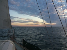
The next morning, we again got underway at 0900, went through the turning basin and headed south through Bogue sound. In Bogue sound we had our third opportunity to raise sail. (The first time was the run from Elizabeth City to Manteo. Crossing Pamlico sound there was almost no wind the first day. But the run from Okracoke to Oriental was a great sail). The wind died later in the day and we continued under power to Mile Hammock Bay. This is open to anchoring, but it is surrounded by Camp LeJeune, so no going ashore here.
We had a nice secure anchorage here, but the next day was almost a disaster. In Beaufort we had swung the dinghy up on deck in preparation to going offshore. We decided to stay inside, but did not put the dinghy back in the davits! On leaving Mile Hammock Bay, I missed seeing the green channel marker for the entrance and ended up leaving it to port after scraping hard against it. No damage except to my pride and a few paint scrapes, no grounding, thankfully, but boy did I feel foolish. Later on, the same day I had another missed green mark with fewer repercussions, but that time I didn’t have the excuse of the dinghy obscuring my vision. Between the Surf City Bridge and the Figure Eight Island bridge I drifted out of the channel, again on the wrong side of a green mark. Luckily we were idling along when I snagged a net on the rudder. The fishermen who were tending the net were not very happy, not that I blame them. I was a little put out that they were so un-friendly and made no attempt to help us free their net and when we did free the net with no damage, only scowls greeted us. I offered to compensate them for their loss, but since there was no damage to the net they scowlingly allowed that there was no recompense necessary. With no damage to the net or the boat, we made it to the next opening of the Figure Eight Island Bridge. After some embarrassing conversations with Rob about me not being careful, and better me than him, we continued south to a nice protected anchorage at Carolina Beach, just north of the Cape Fear river. (The Carolina Beach state park docks were not open).
We are now in day nine of our journey. On this day we continued motoring and made it past the Sunset Beach pontoon bridge, the rockpile, the Barefoot Landing swing bridge, and anchored in a pretty anchorage at Calabash Creek. This is a rather small anchorage, and we dropped anchor at 1602 and there was plenty of room. By dusk, two other boats had anchored quite close to us and I was a little concerned. I talked to the other skippers and they agreed to get up at 0300, along with me due to the tide change to make sure that we swung together and did not entangle each other. Two of us got up, but of course the wind was wrong and the third boat swung into us. The best we could do at that point was to raft up and try to get some more sleep. Of course, the boat with the skipper that did not get up, wanted to be away early, and about 0630 the next morning we had to get up to get him clear. The ironic part of this is that, on leaving he mistook the ICW marker for the entrance marker and ran hard, hard aground. A trawler couldn’t pull him off, so he had to wait for the tide and a tow. Meanwhile we had our usual leisurely start to the day and motored past the unfortunate fellow while he was still hard aground.
On the 28th we continued our journey down the various canals to the Waccamaw river In the Waccamaw river there is an anchorage just north of the Buckport marina that is really eerie. The water is deep, but there are these sunken house boats and various trees sticking out of the water. It looks like something out of a movie about lost places. This is getting a little tedious. Day after day of motoring down canals and rivers.
The next day we go upriver, through a canal, down river, through a canal, up river, through a canal. You get the picture. Current with us, current against us. We end up ain Whiteside creek which was one of the nicest anchorages we found. Lots of room, well protected, good depths. It is a very nice anchorage.
From Whiteside creek, we continued our winding journey southward. It again seemed that we made more miles east and west than south. We passed by Charleston and finally anchored in the South Edisto River. This too was a very nice anchorage.
On leaving this anchorage I had one of my biggest lapses of judgment of the trip. In the morning there was a reasonably thick fog, and I decided to wait it out. We waited a couple of hours, then as the fog seemed to be lifting, we hoisted the anchor and headed out into the main ICW channel. In the main channel the fog thickened again, and kept on thickening instead of lifting. Luckily we kept to the far right of the channel because without any warning, except the thrum of a diesel, there to our right, not about fifty yards away, heading north, was a tug pushing a barge. If we had been in the middle of the channel, there is no way we could have maneuvered out of the way in time. The tug was sounding no horn, and the diesel thrum could have been a mile away. It was impossible to determine if it was getting louder or not. I just about lost it! We were clear; but, such a close call, without any idea that the barge was anywhere near. We immediately headed as far out of the channel as possible and dropped anchor. I rang that damn fog bell as required for about an hour before the fog finally lifted.
There is a lesson in this. If you do not have radar, and visibility is significantly reduced, do not count on signals from other vessels. Find a safe place to go, anchored or otherwise. Stay on the radio and announce your presence. Wow! Was that close to disaster.
During this leg we did have a chance once again to raise sail on the leg up the Coosaw river. At the end of a short day we tied up at the Downtown marina in Beaufort S. Carolina. Not to be confused with Beaufort N. Carolina.
In Beaufort, we checked the weather carefully, and decided that it looked good enough to go outside at Port Royal inlet. The seas were predicted to be two to three feet, with winds from the north at ten to fifteen knots for the next few days.
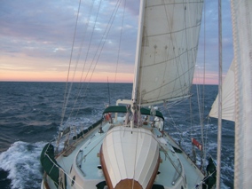
On the first of November, we got underway a little late, 1120, and headed out the inlet on an outgoing tide. On the first we had moderate swells from the east and a moderate chop from the NW. We sailed through the night and during the wee hours of the morning, it appeared that the wind was clocking to the NE. Based on our conditions, we thought about changing course for the St. Johns river inlet, but after listening to NOAA weather we changed our minds and decided to head for St. Augustine inlet. Even though St. Augustine is uncharted, word of mouth had it that it was a pretty good inlet, and with a daytime entrance in moderate conditions, we thought that it would be a good choice. On the second, the wind started to pick up and I decided that with seas running 5 to 7 feet, (NOAA still said 2 to 3 feet), I agonized over whether or not to shoot for St. Augustine. Based on the conditions and again, despite NOAA’s prediction, it looked like the conditions would worsen, so I decided to head for Port Canaveral, whose inlet is passable in virtually all conditions. We sailed through the night in steadily deteriorating conditions, seas mounting and confused, wind in excess of 20 knots throughout. We at no time felt that the vessel was even close to being in danger, but we were getting pretty tired and were grateful to enter Port Canaveral at 0715 on the third of November. I later did some calculations and we had averaged 6.3 Knots for this leg of the trip under sail.
On entering Port Canaveral we tied up at the Cape Marina fuel dock, and asked the dock master if we could stay for a couple of hours while we rested and refreshed ourselves. I was totally astounded when she told me that I needed to fill out “paper work” and that it would cost me ten dollars an hour!!!! I thought for a minute that I must have landed in the red light district!! I still find it hard to believe. Needless to say, we didn’t stay. We got underway, went under the bridge and through the lock and anchored on the west side of the lock for the rest of the day and got some much needed rest. Since we were heading to New Smyrna Beach, we decided to get underway again that afternoon to make it to an anchorage for the night. Unfortunately, the SR 3 bridge over the barge canal does not open between 3:10PM and 5:59 PM and our rest had taken us past the 3:10 PM mark. This meant that we had to go through the bridge and make our way up the ICW to an anchorage at night. This is not a real problem, but it is extremely tiring. We anchored just south of the NASA causeway for the night at 1930. The next day was to take us to New Smyrna Beach, which was the destination for this trip.
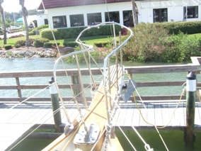
On the morning of the 4th of November we got underway from the NASA causeway with the expectation of reaching New Smyrna Beach in the late afternoon or early evening. We stopped for fuel in Titusville then continued through the Haulover canal to Mosquito Lagoon. The wind was blowing about 20 Kts from the NE so we put up the big jib and really made time through the lagoon. We were doing about 7 Kts under sail and power, when we were easily passed by a Hunter 49, just seemingly cruising under power at an easy cruising speed. I guess the water line length of 49 ft, trumps sail and power with a water line of 31 feet! Hull speed of 9.4 Kts vs. Hull speed of 7.5 Kts. That aside, we made good time and took down the jib when we were well into the Halifax river. I had called my mother and she told me that she had arranged for free dockage for one night at the NSB Yacht Club. It turns out that the slip they had for me stuck out into the Halifax river and was perpendicular to the 2 Kt. Current. I was not familiar with docking with this much current perpendicular to the slip and I made a bad approach from upcurrent. The stern swung around and I was positioned badly. I realized this a little too late, but would have been OK except I compounded the mistake. When I tried to reverse to back away and try again, I was a little too late, and to add to my woes, instead of going into reverse I actually had put the engine in neutral and was simply revving the engine. (I have a single lever control, and if you are familiar with this type of control you can see how this could happen). By the time I realized what had happened I had crashed the bowsprit into the dock. The bowsprit rail looked like a pretzel. What an ignominious end to a great journey.
| Home Dunedin to Chesapeake Oct., 2008 Hampton to Florida Oct., 2009 Florida to St. Mary's County April, 2010 St. Mary's County to Florida Oct, 2014 Hudson to Bahamas and Back June, 2017 Contact Us |